
51-53 Blackfriars Road: deed of 1961.
10 August 2020
For several years Oxfordshire History Centre and Oxford City Council have been engaged in a partnership project to identify and catalogue the City Council’s paper archives, particularly those which have been inaccessible for many years at the Town Hall. One of these is a remarkable collection (containing 116 boxes representing 300 properties) of deeds of properties purchased by Oxford City Council for the redevelopment of St Ebbe's in the late-1950s and early-1960s. In most cases the Council acquired a packet of deeds often going back to the early 19th century.
Broadly the St Ebbe's area extends south-west of Carfax, between Queen Street and the Castle in the north, Castle Mill Stream and the River Thames to the west and south, and St Aldate’s Street in the east. Much of the area was linked to a Greyfriars monastery which was dissolved in the early 16th century. The land was then used as meadow and pasture land and some of it was cultivated as gardens and orchards.
During the 19th century, after the erection of the City gasworks, much of the neighbouring land was sold for speculative housing development. By the early 20th century the area was fairly densely populated and living conditions were considered to be poor, prompting the City Council to look at schemes for slum clearance and redevelopment. In the 1960s-70s most of the houses were knocked down and many streets disappeared to make way for new road schemes, car parks and buildings, including the old Westgate Centre.
These historic deeds record in detail the transformation of this suburb from open meadow and pasture land into a densely populated residential community, and they contain much geographical detail about the area before and during its transformation, as well as fascinating information about the people who lived and worked in the area.
When the City Council purchased the properties it was customary to include with the deed an outline street plan of the property and neighbouring properties. Thus every property can be precisely located prior to its demolition. However detailed plans are sometimes included in earlier deeds which provide an insight into not only contemporary features but also changes through time, as the following examples demonstrate.
The first plan shows a row of terraced houses with gardens and one or two outbuildings next to the river. However a deed of 1861, covering a slightly larger area, shows a significantly more complex arrangement of buildings, gardens, etc. Note the locations of the cottages, gateway entrances, yards, wash houses, gardens, gig house and stable, boathouses, stairs, fishing balcony, and garden with a fishpond!
51-53 Blackfriars Road: deed of 1961.
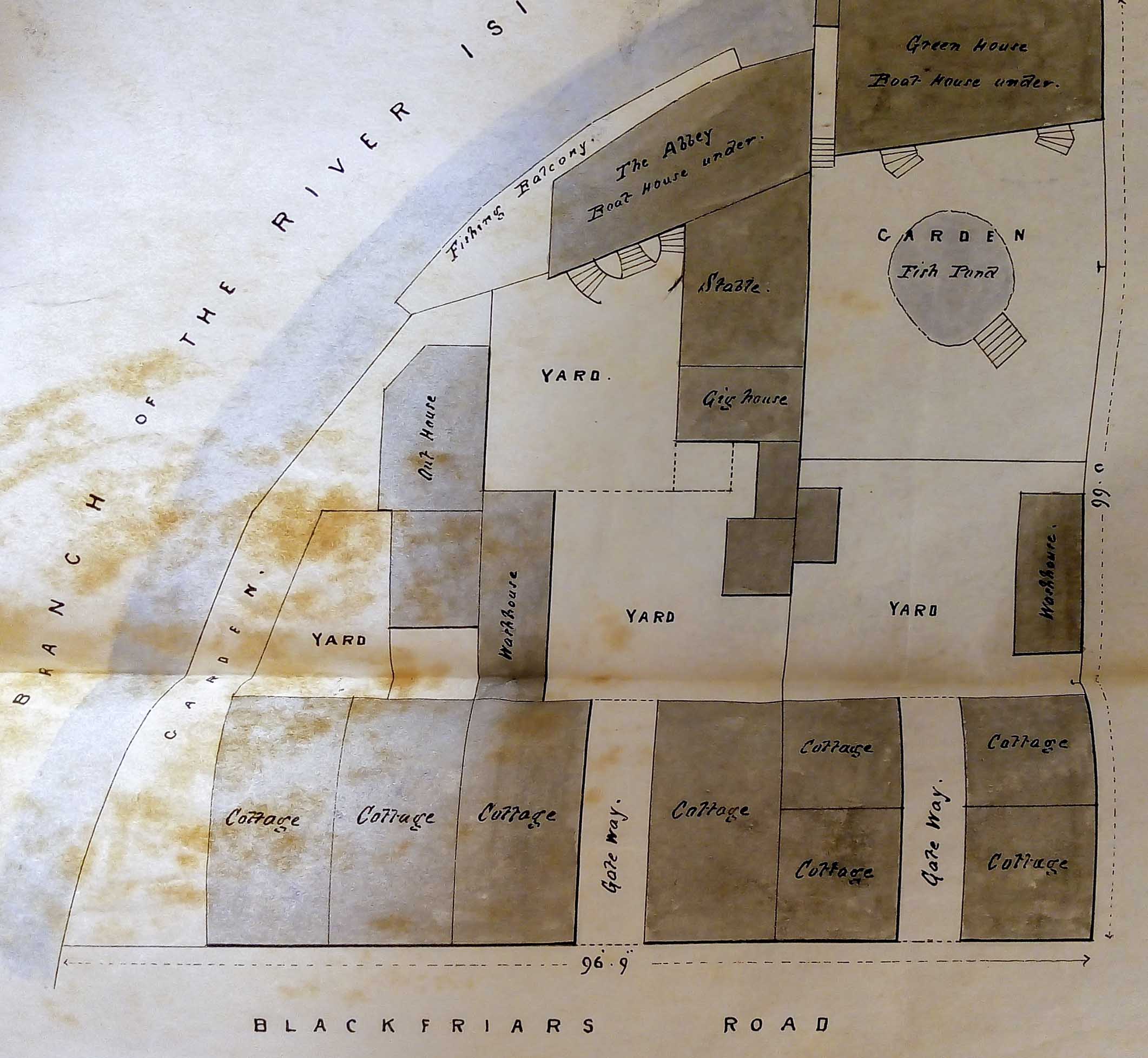
51 Blackfriars Road: deed of 1861.
The conveyance of 1877 shows in fine detail a complex of buildings which had become a bakery. In 1833 numbers 2 and 3 were sold separately as empty pieces of land. By 1849 2 and 3, along with the land at the back leading to Friars Street, had been acquired by Michael Mercer of St Ebbe’s, initially described as a plasterer and later grocer. It seems to have been him who built the first bakery with the old bakehouse which he then sold in 1866.
In 1871 number 4 was acquired by James Cooper a baker and grocer who then acquired 2 and 3 in 1873. Presumably he adapted the whole complex and built the new bakery. However, he must have had financial problems, because he filed for bankruptcy in Oxford County Court in May 1877. From that date onwards, although the combined premises are still described as a bakery in later conveyances, none of the later owners are identified as bakers, or lived on site (although it could have been operated by tenants) and, by the time the City purchased it in 1956, it is described as a former bakery.
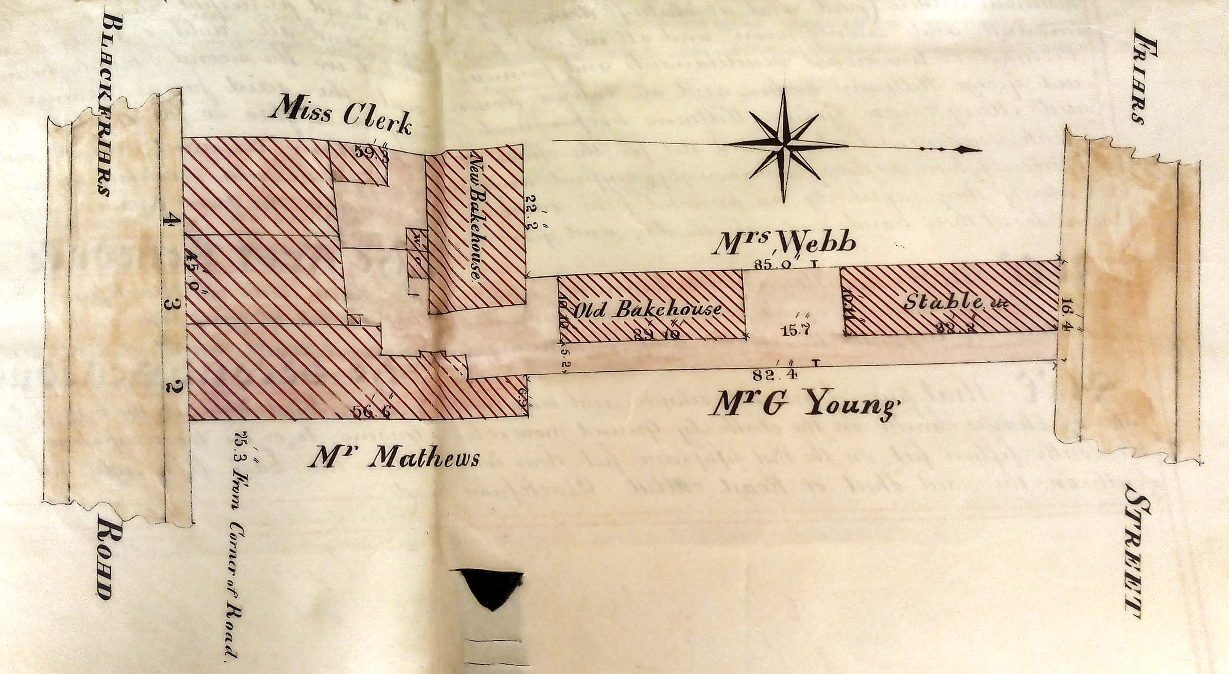
2, 3 and 4 Blackfriars Road: deed of 1877

2, 3 and 4 Blackfriars Road: deed of 1956
The deed of 1867 contains a highly detailed plan of a workshop or warehouse and yard, which is unusual. It shows rooms and separate stalls within them, as well as stairs and possibly privies and or sinks / wells. It was located next to the river and owned by Jason Saunders, described initially as a carrier and later as a railway agent. Clearly, he used these premises to store his equipment and operate his business transporting goods presumably in conjunction with the new railway station nearby. The premises were located next to premises owned by the Oxford Local Board (which in 1966 are identified as the City Council’s Isis Street depot or wharf), by which time they were owned and operated by The Coca-Cola Bottling Company (Oxford) Limited, whose head office was registered at Riverside, Grandpont!

13 Thames Street: deed of 1867

13 Thames Street: deed of 1966
Unfortunately these records are not accessible to the public at the moment due to restrictions. However, it is hoped that once cataloguing is completed, a new catalogue will be made available online, and researchers will be able to access the documents in the next few months.
The Oxford City Archive project is currently administered by the Museum of Oxford.
Posted by: Chris Gilliam, Archivist, Oxford City Archive