Introduction to the Oxfordshire Field-Name Survey
How the Survey was created, and an assessment of field-names in the Oxfordshire landscape
Origins of the survey
M40 Research Group
The Oxfordshire Field-Name Survey was pioneered by the Field Section of Oxfordshire County Council's Department of Museum Services. In 1970 there was a need to identify potential archaeological sites which lay directly on the route of the planned extension to the M40 motorway between Stokenchurch and Waterstock, so the Oxford City and County Museum (based at Woodstock) embarked on a joint project with Oxford University's Department for External Studies to set up an M40 Research Group. The project target area was then expanded in 1972-3 to cover the survey corridor of the further M40 extension from Waterstock, north to Banbury and beyond.
Creation of transparent map overlays
The process of systematic recording was begun in 1970 by Assistant Field Officer, Mick Aston. To make the interpretation of field-names in their landscape easier, Mick conceived the idea of plotting the names onto transparent overlays which could be viewed over the Sites and Monuments Record's 1:10,560 scale Ordnance Survey record maps. These field-name transparencies became a core research dataset of the County Council's Sites and Monuments Record, and were transferred to Oxfordshire History Centre in 2011. They have been digitised for online presentation here.
Volunteers and the Oxfordshire Federation of Women's Institutes
The survey project started by Mick Aston was continued by James Bond on his return to Oxfordshire in 1974. It was well supported by volunteers from the outset, and significant among these was Elizabeth Leggatt, who continued working as a volunteer for the Sites and Monuments Record into the 1990s.
The inital volunteer effort gained momentum later in the 1970s when the Oxfordshire Federation of Women's Institutes approached the Museum Service for guidance on undertaking a project on field-names. The WI members' particular contribution was the collection of field-names still in current or recent use by those who had actually worked on the land; many members wanted to take their research further and transcribed field-names from estate maps and tithe maps that were publicly accessible at the time.
Use of index cards
In around 1979 more intensive survey work was carried out in Swalcliffe, Hook Norton and Adderbury by Oxford University extra-mural students, under the guidance of tutors Kate Tiller and Sarah Gosling. Field-names were captured onto index cards, taken from a wide range of archive documents, published histories, and oral testimony. This allowed the use of names to be related and compared across multiple sources of evidence.
1982 report on the Oxfordshire Field-Name Survey
You can learn more about the development of the Oxfordshire Field-Name Survey in James Bond's 1982 journal article below. The article also reviews some examples of Oxfordshire field-names and their links to social and economic history, or to archaeological and geological evidence in the landscape.
The article text is reproduced in full from O.L.H.A. newsletter, vol. 1, no. 4, Spring 1982, pp. 2-15. We are grateful to James Bond (author) and the Oxfordshire Local History Association (publisher) for their kind permision to reproduce it.
The original article, as published in 1982, can be accessed here.
Oxfordshire field-names: a progress report on the county survey
James Bond
The investigation of the names of fields has long been regarded as one of the more esoteric byways of historical studies, of passing curiosity for the parochial historian, but of no real wider significance. Local histories published since the late nineteenth century would often dutifully include a selected list, sometimes even a map, of field-names in their chosen parish, either before or after enclosure, and might indulge in a little antiquarian speculation over their naming. It is only within the last thirty years, however, that fieldnames have become the object of serious study.
A major landmark was the publication of the two Oxfordshire volumes of the English Place-Name Society (E.P.N.S.) in 1953-4. ref 1 Here for the first time an attempt was made to list and trace the derivation of field-names over a large area according to genuinely scholarly principles. Given the format of the Society’s volumes, it was recognised that a comprehensive coverage would be impossible; the survey therefore aimed at presenting only what was regarded as a representative selection of field- names from each parish. The basis of this was normally the Tithe Award, or, where this was not available, the Enclosure Award. Lists of field-names from earlier sources such as terriers and court rolls were also included. Some modern names were also collected, and it was recognised that much more work could usefully be carried out in that direction. A valuable appendix identified and interpreted many of the common elements which recur in minor place-names and field-names. Coverage for the Vale of White Horse on a similar pattern became available when the three Berkshire volumes of the E.P.N.S. were published during the early 1970s. ref 2
Perhaps the most important lesson to emerge from the E.P.N.S. surveys was that a minority of field-names could be of unexpected antiquity, a point which has become increasingly clear in subsequent studies. To take just a couple of examples: the bounds of an Anglo-Saxon estate at Pyrton described in an eleventh century charter intersected two landmarks whose names survive in fields called Fleet Meadow and Crippshill; while Nuneham Courtenay and Batham in Radley can be identified by name in the obedientiars’ accounts of Abingdon Abbey in the fourteenth and fifteenth centuries. Even names which sound relatively modern and uninteresting may prove to be surprisingly early. There is a Footeball Close recorded in Wootton by Woodstock at the beginning of the seventeenth century. At Cogges a field with the not very exciting name of Eight Acres can be identified beyond any doubt with a meadow of the same name mortgaged by Richard Wright of Gill Mill in 1633 to Robert Veysey of Chimney; the same field is named on the bounds of the manor in 1669. The late names themselves are not without interest: what in particular inspired the naming of a particular field Klondyke in Kingham, or Waterloo and Blenheim in Shipton-under-Wychwood? Enstone has a particularly good range of such commemorative names, including Pretoria, Victory Ground, Armistice Acres and the somewhat tongue-twisting Peace Piece.
The listing of field-names parish by parish is a useful exercise in so far as it facilitates etymological study - especially where a sequence of names from sources of different dates has been collected. However, the weakness of the E.P.N.S. format is that the essential relationship between the name and the parcel of land to which it referred is lost. Rather like a group of unprovenanced artefacts in a museum, the listed names may be of considerable intrinsic interest, but are unable to tell us much about the area from which they have come.
The plotting of names on maps is an essential next step. The true significance of whole classes of names which seem to imply a shape, size or position can then begin to be evaluated. For example, amongst the names often taken to indicate remoteness and inaccessibility, World's End in Westwell and Curbridge, Botany Bay in Stanton St. John and Cassington, and Van Diemons (sic) in Hethe, all occur out in the far corners of the parish on the boundary; but California in Shipton-under-Wychwood lies in the centre of the parish, only 500m east of the village centre, and is presumably a commemorative name recalling the gold rush rather than an indicator of remoteness.
The ultimate value of collecting field-names can only begin to be realised, however, when they are stored alongside a fully comprehensive collection of geological, archaeological, historical and topographical records. The development of a data bank for Oxfordshire, the Sites and Monuments Record, maintained by the Field Section of Oxfordshire County Council's Department of Museum Services at Woodstock, together with the Biological Record System housed in the same building, has been described elsewhere and need not be discussed further here. ref 3
The addition of field-name coverage to the Museum records was begun during the preliminary documentary investigations carried out to assess the archaeological implications of the construction of the M40 motorway from Waterstock crossroads to Stokenchurch in 1970. The field-names were plotted on to transparent overlays which could be read over the basic 1:10,560 record maps containing the archaeological and topographical information. Names from different sources were distinguished by different scripts, symbols and coloured inks, for which a key was provided at the foot of each overlay.
The value of storing such details in this way quickly became apparent, and a project to extend the plotting of field-name overlays over the whole county was commenced by Michael Aston, then Assistant Field Officer at the Museum. This project has been continued by the present writer since 1974. The bulk of the work has been organised at parish level in collaboration with the Oxfordshire Federation of Women’s Institutes. Twice yearly representatives from W.I.s in the county have met for instruction on the nature and purpose of the project and the documentary and oral sources which are available. The particular strength of the W.I. contribution has been the recording of current names from oral sources - as most members are likely already to be known to local farm workers and elderly inhabitants, they have much readier access to such information than an outsider. The Institutes submit their completed maps to the Museum, the details are transcribed onto the overlays in the Sites and Monuments Record, and the original maps are then returned to the compilers, together with a commentary on any local names found to be of particular interest, to be kept in the parish.
In certain parishes very valuable work has also been carried out by local archaeological and historical societies and by unattached individual volunteers. Within the overall responsibilities of the Museum’s Field Section it has never been possible to accord a particularly high priority to allocating time for the promotion of the field-name survey; despite this, at the time of writing (February 1982) substantially complete surveys have been deposited for eighty parishes, partial surveys are held for another thirty parishes, and work is actively progressing in another ten. (see Fig. 1).
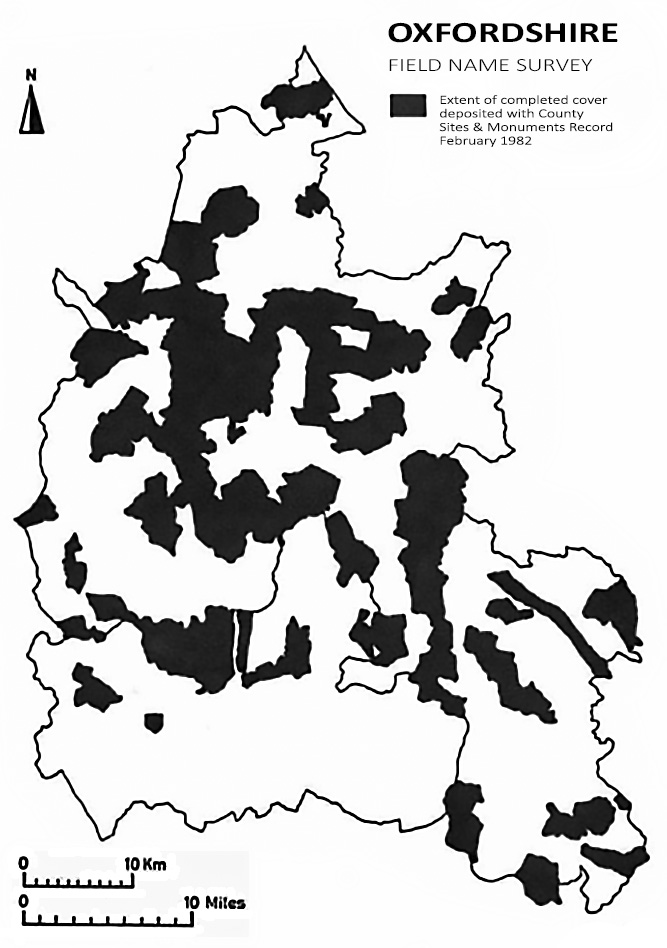
Fig. 1. Oxfordshire Field-Name Survey coverage map, 1982
The first advantage of plotting field-names on maps housed within a complete environmental record system is that the origin of some of the names can be explained by reference to other parameters which are already mapped. For example, the names White Quarry Hill and Red Quarry Hill in Kingham are immediately understood when, on checking against the Geological Survey, the former is seen to lie over the cream-coloured Chipping Norton Limestone and the latter over the orange-brown Marlstone of the Middle Lias. Derogatory names such as Starveall (Bucknell, Stanton St. John, Hinton Waldrist, Longworth), Looseall (Garford), Small Gains (Minster Lovell, Great Coxwell, Buckland, Hinton Waldrist) and Sour Land (Swalcliffe, Cassington) are common, and it would be instructive to check these comprehensively against the Agricultural Land Classification maps - a random sample of half a dozen examples proved to be entirely on land classified today as Grade III or Grade IV.
A second benefit from direct plotting is that some light may be thrown on the chronology as well as on the meaning of the name. Names describing field shape are a common and widespread category. Of the parishes so far surveyed in detail, fourteen examples of names indicating triangular shape have been detected. However, three of these - Triangle in South Leigh, Three Cornered Field in Cassington, and Three Cornered Bit in Cropredy - can now be recognised as the residual corners of larger rectangular fields cut off by the construction of the railway.
From the archaeologist’s point of view, it has long been recognised that certain names can reflect the presence of ancient settlements, burials or other features; and, conversely, therefore, the appearance of one of those distinctive fieldnames where no site is known might lead towards the discovery of a previously unrecognised site. The plotting of fieldnames on a county scale as part of a Sites and Monuments Record makes feasible the testing of the frequency of correlation between distinctive field-names and known sites; and may ultimately allow us to derive a prediction for the reliability of particular names as site indicators on a percentage basis.
With this possibility in mind, it is worth exploring a few examples. The Old English words beorg, meaning either a natural hill or a burial mound, and burh, meaning a fortified site, both frequently appear in field-names in the form ‘Barrow’, ‘Borough’, ‘Bury’ or ‘Berry’. Unless early forms of the name survive, it may be impossible to ascertain from which of the two roots the modern name is derived. Of the ten field-names so far located which incorporate the modern form ‘Barrow’, five of them clearly relate to known tumuli, one contains a henge monument and one contains a rectangular earthwork of unknown origin. In Forest Hill a field called Barrow Hill very probably pinpoints the previously vague siting of the ‘Two ... little barrows (on Shotover Hill) on the left side of the road from Oxford to London’ mentioned by Dr. Plot in 1677. Only two ‘Barrow’ names do not yet relate to any known site, but the ‘success-rate’ of the name elsewhere is so high that they might clearly repay investigation. Of the ‘Borough’ field-names so far located, one contains a burial-mound, three more contain Iron Age sites, but the remaining seven occurrences as yet have no known archaeological significance. The modern ‘Bury’ and ‘Berry’ forms have been less productive still: twenty located examples do not correspond with any known site, and only two cases - Old Bury at Tetsworth and Grass and Corn Forbury at Garford - seem to have a significant juxtaposition with a village or manorial complex. At Tetsworth excavation in advance of construction of the M.40 in the field immediately adjoining Old Bury located an enclosure with a bank and deep ditch containing a fairly substantial farmhouse and croft of Norman date.
Fourteen examples of the name ‘Round Hill’ have been located. In some cases, e.g. in Tadmarton, Churchill and Chalford in Enstone, this is clearly simply a description of the natural topography. However, the name is also given to fields at Over Norton, Eynsham, and Lidstone in Enstone which contain tumuli or ring-ditches. It ls clearly worth closer investigation wherever the natural configuration of the ground does not itself seem to merit the description.
The name ‘Blacklands’ is often quoted as an example of an archaeologically significant field-name: the theory being that long-continued human occupation on a site leads to a build-up in the organic content of the soil, leading to localised darkening, which was recognised by subsequent generations of ploughmen long after the site was abandoned and forgotten. Of eleven examples in Oxfordshire whose locations have so far been pinpointed, one in Sandford St. Martin has produced prehistoric flint tools and waste; one in Somerton contains crop marks of ditches, trackways and enclosures of unknown date; one in Abingdon contains the complex of prehistoric and Romano-British settlements excavated by the Oxfordshire Archaeological Unit in the 1970s on the present Ashville Trading Estate site; two examples at Swalcliffe Lea and Pusey also contain substantial Romano-British settlements; and an Anglo-Saxon shield boss has been found in Blacklands at Sydenham. This still leaves five examples which have not yet produced any archaeological evidence, and these again require further examination.
The various names which may relate to deserted medieval villages provide another fruitful area of study. Sometimes the actual name of the village itself appears: Green and Corn Benny in Clanfield, Edgerley Ground in Ducklington, Asham Mead, Marsh and Field in Horton-cum-Studley, Topples Ground and Wood in Finstock, Berrings Plain and Wood in Glympton, and a whole block of Coomb names in Great Milton. The problem with these, however, is that they are as likely to refer to land which formerly belonged to the village as to the settlement site itself; or they may even appear in a neighbouring parish where its lands lay adjacent to the bounds of the deserted township. This probably accounts for the names Great and Little Hamstall Piece in South Leigh, which occur some 500m west of the actual site of Hamstall village in Eynsharn parish.
Field-name evidence has recently played an important part in the rediscovery of the site of the hamlet of Saxinton in Bucknell parish. In 1695 White Kennett described ‘Saxenton in the parish of Bucknell, where the foundations of building do more especially appear in a ground called the Ball-yards’, and the site was still remembered in 1823, when Dunkin wrote that ‘A short distance from Bucknell church ... are numerous foundations of houses, which once constituted the village of Saxenton’. Subsequently the site was forgotten, until a W.I. survey in 1977 produced a field called Bolliers, a name recalling White Kennett’s Ball-yards. On checking the air photographs, faint rectilinear marks which may well represent ploughed-out house platforms and an old roadway could just be detected in the field. Interestingly also, the little wood immediately to the north was called Nettle Copse, and nettles are notoriously profuse on such sites due to the change in the phosphate balance of the soil in areas of former settlement.
‘Town’ names have also been used to locate deserted villages: the field containing the earthworks of Lower Chalford in Enstone was called The Towns in 1743, the site of Lea in Swalcliffe is called Town Ground, while the field containing the former village of Eaton Hastings is called Old Town. However, ‘Town’ names are not restricted to deserted settlements, but have also been noted immediately adjacent to ten existing villages. Similar juxtapositions with deserted villages may also be expected, and in four cases noted so far, ‘Town’ names designate not the settlement site itself, but the adjoining field. ‘Town’ names also may indicate meadows or other land formerly communally owned; ten located examples are remote from any known settlement, and it is highly unlikely that they all represent otherwise unknown deserted villages.
‘Church’ and ‘Chapel’ names are another group to be used with caution. Sometimes they do indeed indicate the site of a former ecclesiastical building: Chapel Leys in Wootton is adjacent to the deserted village of Hordeley, which had its own chapel in the 13th century, while the Chapel Close now inside Chiselhampton Park records the site of the medieval predecessor of the present Georgian church. More frequently, such names simply record former glebe land. One puzzling group of names remains: Old Church in Great Coxwell, Old Churchyard in Middleton Stoney, Church Yard in Chalgrove, and Fallows Churchyard in Brightwell Baldwin. These names seem to imply some specific structure or feature, yet they all lie towards the margins of their parish, distant from any known church or graveyard. Clearly this phenomenon requires further investigation.
Field-names can also suggest the presence of many other archaeological features. Fields called Stratford Meadow and Stratford Furrowlong in Chalgrove incorporate the element straet, meaning a made road probably of Roman date: though not near any officially-recognised Roman road, it may well be significant that they lie adjacent to a long straight hedge followed by the parish boundary for 1.4 km, pointing directly towards Dorchester. Another Stratford Field in Kingham may also commemorate an otherwise unknown Roman road: there is a known Romano-British settlement about 1km away.
Industrial sites are frequently commemorated. Names indicating kilns of various sorts are especially common. Of the fifteen names referring to limekilns so far located only one is known to contain extant remains of the kiln, while another five retain no signs of kilns but do contain evidence of small quarries where limestone was worked. Brickworks have sometimes left similar traces in field-names. In 1534 a contract was drawn up between the Warden and Fellows of New College, Oxford, and two brickmakers named Richard Whytby and Clement Peake of St. Giles-without-Cripplegate, London, to make 500 000 bricks at Stanton St. John in three kilns or clamps: the field-names Kiln Ground and Hell's Kitchen, both on Oxford Clay outcrops suggest possible sites of their activities, since no other record of brick-making in this parish has yet been encountered. Vanished mills are also commemorated. Mill Close in Little Tew still contains the earthworks of the pond system of a demolished watermill. ‘Windmill’ names may sometimes record sites of considerable antiquity. Windmills are recorded at South Stoke in the 1220s, at Beckley in 1277-8, at Garsington in 1308 and at Hinton Waldrist in 1360, and their sites are possibly recorded by names in those parishes, Windmill Ash Field, Mill Field, Windmill Hill Furlong and Windmill Hill respectively. Windmill Furlong Piece in Buckland still contains the windmill mound which is probably the site of the mill recorded in 1647.
As field-name information continues to accumulate alongside other material in the Oxfordshire Sites and Monuments Record, in addition to contributing details relevant to individual sites, it also begins to illuminate the broader issues of landscape history in the county as a whole. While it would be premature to attempt to draw any conclusions from the distribution of field-name elements before a greater proportion of the county has been covered, nonetheless already some interesting points seem to be emerging.
For example, names including the element ‘Assart’ or ‘Sart’, a Middle English word meaning recent clearing from waste or woodland, appear to be concentrated almost exclusively in West Oxfordshire between the Windrush and Glyme. Since the fringes of Wychwood Forest in this area are known to have been undergoing active clearance and colonisation during the Middle Ages, this does not come as any particular surprise. The name ‘Breach’ derived from another Middle English word which seems to have similar meaning of ‘land newly taken into cultivation’ might be expected to have a rather similar distribution; yet, while there is some overlap in the southern fringes of Wychwood, no ‘Breach’ names have so far been located in the central Wychwood parishes, but they do occur in widely scattered locations throughout much of the rest of the county. Neither ‘Assart’ nor ‘Breach’ names have yet been collected from the Chilterns. A third word, ‘Grub’, which again seems to apply to cleared land, is common in the Chiltern parishes, but appears rather rare elsewhere. The implication may clearly be that there is some fundamental distinction historically between these three field-name elements, despite the fact that their meaning is superficially rather similar.
The common field-name ‘Lanket’ is a dialect word for a long, narrow field; and, being a term merely descriptive of shape, might not be expected to be of much interest; however, its distribution as recorded at present is strikingly concentrated in central and west Oxfordshire, and it is so far absent from the north, north-east and south of the county. ‘Slinket’, which appears to have an identical meaning, has an almost exclusively northerly distribution - only one example so far has been recorded south of the Chipping Norton-Deddington line. Such contrasts in distribution would appear to have some significance, although their meaning is not yet understood.
Names indicative of former crops may reveal distributions of interest to agricultural historians. One of the new leguminous crops introduced into England in the mid-seventeenth century, which on being accommodated into the rotation allowed the redivision of the open fields and the reduction of fallow, was sainfoin. From documentary sources it is clear that this crop was widely adopted over the lighter upland soils of North Oxfordshire during the late seventeenth and eighteenth centuries. Some thirty field-name references to sainfoin have been collected, widely scattered across the central part of the county, thinning out in the extreme north and in the Vale of White Horse, and so far entirely absent from the Thame Valley and the Chilterns. Over forty field-names indicating former hopyards have been traced, and these too are fairly widely distributed, except on the higher parts of the Chilterns and in the country between Wychwood and the Upper Thames.
The initial objective of the Oxfordshire Field-Name Survey project has been to acquire a total coverage of the county as soon as possible. Because volunteers often without any sort of historical training have been so extensively involved, the design of the project as a whole has been kept as simple as possible. The choice of sources used has been left to the individual volunteer, with the essential proviso that, whether the names are collected from documents or from oral evidence, the source of each name must always be identified. Once the county coverage built up in this way is reasonably comprehensive, the way forward then will clearly be to return to the level of the individual parish and to investigate the origin and development of the name of each field in greater depth from a wide variety of sources. The first attempt at this more intensive level of survey was begun in 1975 as part of the County Museum Service's research project on the former parish of Cogges, in association with the development of its branch museum at Manor Farm. More recently detailed surveys have been undertaken in Swalcliffe, Hook Norton and Adderbury by extra-mural classes organised by Oxford University Department for External Studies. The method of recording at this more detailed level, evolved by the tutors Kate Tiller and Sarah Gosling, is briefly described below, as it may be useful to other Oxfordshire historians undertaking this kind of work.
As soon as a systematic search for field-names is commenced, it soon becomes apparent that the range of source materials is very large, and that some means of bringing together all references for an area is necessary. Many references to a named field are accompanied by other valuable local information: how the land was being used at a particular date, its owner and/or occupier, the size of the field at a known time. In this way the field-name can be a key to further knowledge of the agricultural and economic organisation of the community and of its social structure. In order to make the maximum use of this information, and on the principle that if one is going to record one fact from a map, or a document, or an informant, one may as well record any other points that can be discovered, a standard index card was designed.
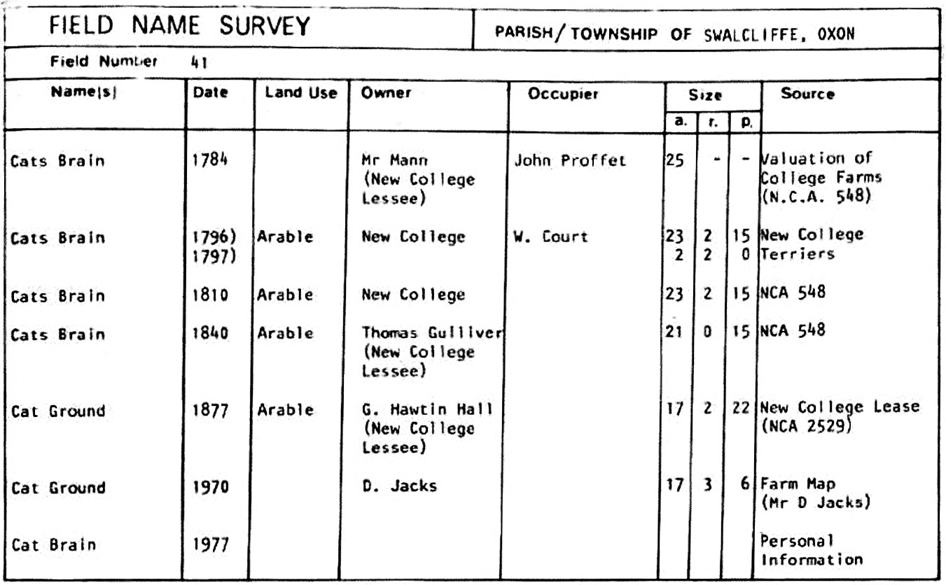
Fig. 2. Sample index card from the Oxfordshire Field-Name Survey
This fits conveniently on to an 8" x 5" card or, less expensively, two forms will fit onto an A4 paper sheet for duplicating. Each earn refers to a field numbered on a key map of the parish. A base map drawn from the Ordnance Survey 1:10,560 Provisional Edition of the 1950s-60s was used. The field boundaries shown on maps of that vintage were found to correlate readily with the fields of 18th, 19th and 20th century date which were being recorded. Enclosure boundaries were still in existence or could be traced from earlier maps and evidence on the ground. In this way the survey provided indications of two phases of landscape development, firstly the tendency towards later subdivision of the larger fields created by parliamentary enclosure, secondly a record of lost hedgerows cleared in recent years in the cause of ‘prairie’ farming.
This continuity of field-names enabled fuller use to be made of references to landownership and land use occurring in documents not themselves accompanied by maps; and enabled new maps of ownership and land use to be attempted. This was particularly valuable for the late 18th and 19th centuries when estate documents became more numerous. In addition, certain field-names obviously bridged the great divide of enclosure. As one recent study has shown, the plotting of the location of such names can reveal interesting indications of earlier open-field pattern. ref 4 Working backwards from known evidence can also illuminate earlier sources, as was found in the case of pre-parliamentary enclosure terriers for Swalcliffe or medieval monastic cartularies for Hook Norton. By such means, clues indicating a two-field system at Hook Norton, based on an East and West Field in the thirteenth century, but changing to North and South Fields with further subdivisions by the seventeenth century, were identified.
In this way, a field-name survey proved an excellent way of getting to know a wide range of sources: valuations, leases, estate correspondence and maps, terriers, tithe and enclosure documents, sale catalogues, probate records, monastic cartularies, present-day farmers and local people and many more, were all tapped for information. The field name survey not only proved a worthwhile exercise in itself, but it could also lead to very much more.
Notes
- M. Gelling. The Place-names of Oxfordshire : English Place Name Society, Vols. XXIII-XXIV (1953- 4).
- M. Gelling. The Place-names of Berkshire : English Place Name Society, Vols. XLIX-LI (1971-4).
- [Oxfordshire Sites and Monuments Record]
- D. Benson. A Sites and Monuments Record for the Oxford Region, Oxoniensia Vol. XXXVII (1972), pp.226-237
- C.J. Bond. The Oxfordshire Sites and Monuments Record, Oxon. Local History Newsletter No. 5 (1978)
- C.J. BOND & J.M. CAMPBELL, Environmental Record Centres as a Source for Landscape Historians, in P. Brandon & R. Millman (eds.), Recording Historic Landscapes, Principles and Practice (North-West London Polytechnic, Dept. of Geography Occasional Papers no. 2 ,1980).
- R. Workman. Analysing a Tithe Map in Depth, Local Historian Vol. 14 no. 5 (1981).
See also:
- J. Field. English Field-Names: A Dictionary (1972)
- J. Field. Progress in Field-Name Studies, Local Historian Vol. 13 no. 7 (1979)
- H.D.G. Foxall. Shropshire Field-Names Shropshire Archaeological Society (1980)
- R.T. Lattey. The Field Names of Enstone and Little Tew, Oxon., Oxoniensia Vol. XVII-XVIII (1952-3) pp.265-6, and Vol. XXI (1956) pp.84-5
End of 1982 article text
Further Reading
- P. Cavill. A New Dictionary of English Field-Names (EPNS, 2018)
- J. Carroll and S. Kilby. 'Preparing the Ground: Finding Minor Landscape Names in Medieval Documents',The Local Historian, Vol. 49 no. 4 (2019), pp 276-300
- Stephen Mileson and Stuart Brookes. Peasant perceptions of landscape : Ewelme hundred, South Oxfordshire, 500-1650 (OUP, 2021)