Oxfordshire roads and bridges maps - introduction
Oxfordshire County Council historic survey of roads and bridges, 1905
What are these maps?
- These maps were prepared by the County Surveyor, Sidney Stallard, in 1905, under the authority of the Oxfordshire County Council Roads and Bridges Committee.
- Stallard had taken over as from Henry Tollitt, as County Surveyor, in July 1904, and presumably decided a new and comprehensive survey of the county's roads and bridges was needed, to fulfil his duties.
- The committee minutes for 17 October 1904 record the authority given to Stallard to purchase a set of Ordnance Survey six-inch maps for the Council's new survey of roads and bridges:
- The resulting bound volume of maps bears the following manuscript note:
“These maps were prepared to indicate the position regarding Main Roads, before and after the establishment of the County Council in 1889, and [to] indicate Highways Districts.” - Ordnance Survey first edition six-inch to one-mile (1:10,560) scale base maps, published in 1880, were used as a base on which the line of Main Roads, the location of County Bridges, and the boundary of Highways Districts, were marked.
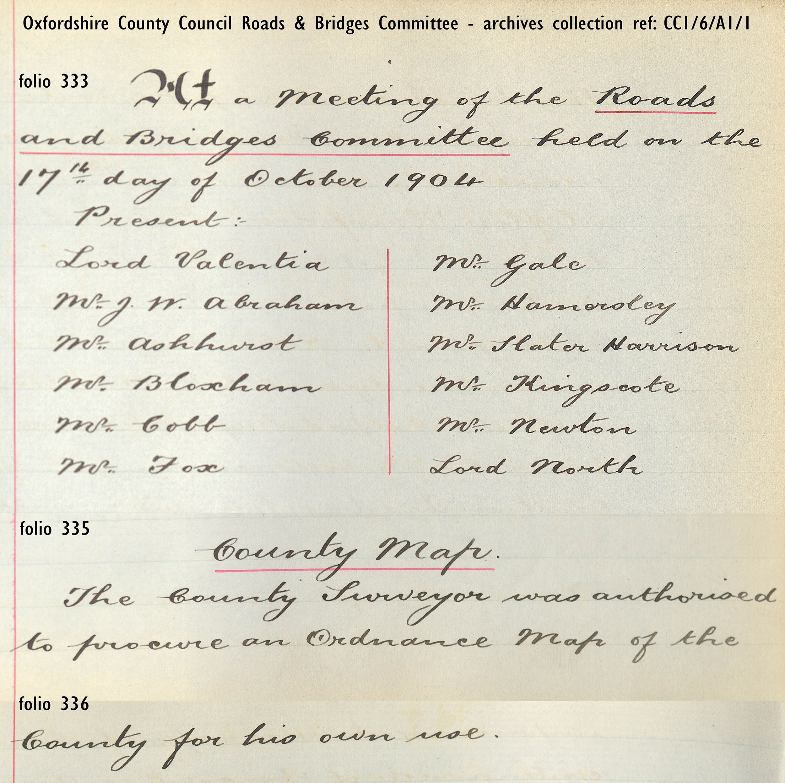
Oxfordshire County Council Roads and Bridges Committee minute, 17 October 1904
Reference: CC1/6/A1/1
Legal and administrative background to this survey
Oxfordshire County Council appears to have made its 1905 survey of roads and bridges in response to Acts of 1878, which introduced the concept of ‘main roads,’ and 1888, which made the county authority responsible for them, while the district highway boards remained responsible for the ‘ordinary’ or local roads. This perhaps explains Oxfordshire's use of the Ordnance Survey 1st Edition base maps (published 1880), which were closer in time to the 1878 / 1888 Acts, rather than the 2nd edition maps (published 1900).
The relevant legislation of the period enacted these changes of administrative responsibility:
- Highways Acts of 1862 and 1864 gave Justices of the Peace the power to compel parishes to merge into Highway Districts, but in many areas Highway Boards were never set up.
- The Highways and Locomotive (Amendment) Act 1878 c.77, sections 13-20, allowed highway authorities to apply to the county authority (Quarter Sessions) for an order to declare highways as main roads, which would then have half the maintenance expenses paid for by the county authority. The ‘ordinary’ or local roads were still the responsibility of the highway authority. Sections 21-22 of the Act refer to ‘Bridges’.
- The Local Government Act of 1888 c.41 established County Councils, which became responsible for ‘main’ roads (section 11 of the Act), inheriting many former turnpikes. In urban areas, Districts were able to opt to take on responsibility for their main roads, while in boroughs and cities with large populations newly formed County Borough Councils became responsible for all highways. County Councils also took over responsibility for major bridges – these had formerly been directly managed by the Justices.
- Under the Local Government Act 1894 – Highway Boards ceased to exist and the highway functions of Highway Districts and the remaining parishes were transferred to newly created Rural District Councils, although Oxfordshire County Council postponed this transfer of powers until March 1896. County Councils continued to be responsible for main roads and County Borough Councils for all highways in their area.
- The Local Government Act 1929 (section 29) abolished the concept of a ‘main road’ and introduced a new concept of ‘county road’. Rural District Councils ceased to act as highway authorities and all their highways (including public paths) were passed to the County Councils. These routes, together with the former ‘main’ roads, became identified by the term ‘county road’. The legislation greatly increased the number of routes for which County Councils were responsible.

Steam-roller in the Fringford area, c. 1894-1910
Reference:
POX0626416
This steam-powered road roller bears the nameplate 'Bicester Rural District Council', and probably relates to the period 1894-1910 when rural districts could contract with county councils to maintain the roads in their districts.
Related material - the County Bridges Book
- Alongside this map-based survey of roads and bridges, in December 1904 Oxfordshire County Council compiled a 'County Bridges Book' - Oxfordshire: county bridges repairable by the County Council, 1905 - which listed all 138 bridges in the historic county.
- Oxfordshire History Centre's broader archive collection of County Bridge Papers (QSB) contains another copy of the 1905 'County Bridges Book', with later detailed manuscript annotations.
- Click or tap the button below to view the full text of the annotated 1905 'County Bridges Book' (pdf, 23 pages, 9.9Mb).
- Manuscript annotations in the 1905 'County Bridges Book' include 'QSB' number references. These refer to documents which relate to individual bridges, in the County Bridge Papers (QSB).
- Note, though, that the bridge number printed in the 'County Bridges Book' is different from the QSB document reference. For example, Cuddesdon Bridge is bridge number 44 on the map and printed in the book, but the Cuddesdon Bridge documents form the collection reference QSB/57.
- John Marriott Davenport, Clerk of the Peace, first compiled the 'County Bridges Book' in this printed summary format in 1845, with revisions in 1853, 1869, 1885, 1889, 1904 and 1905 - reference: County Bridge Papers (QSB/39), with additional copies of 1885 and 1889 - reference: SZ 725.98/(OXF), barcodes 306290221 and 306290222. The County Bridge Papers QSB/39 also contain early manuscript draft lists for Oxfordshire (1842-1846) and printed lists of Berkshire bridges (1880, 1898).
- Henry James Tollitt, of St Aldate's, Oxford, already acting as 'temporary surveyor', was formally appointed as County Surveyor at the Trinity Quarter Sessions of 1879. Tollitt's considerably more detailed report on County Bridges was compiled in 1878 - reference: SZ 725.98/(OXF), barcode 306290215 which records findings gathered in 1876-7, and contains additional manuscript pages and notes, reporting work carried out on the bridges.

Sample text from: Oxfordshire: county bridges repairable by the County Council, 1905, page 18
Related material - the County Bridges Album
- Before Oxfordshire County Council was formed in 1889 and became a major highways authority, the County’s magistrates had a legal duty to maintain County bridges. This could involve substantial cost and it was crucial to be clear who was responsible for which bridge.
- John Marriott Davenport, Clerk of the Peace between 1831 and 1881, provided legal advice to the County for half a century and built up an encyclopaedic knowledge of the County’s bridges as the County fought legal battles over liability to repair decaying structures.
- Davenport needed a visual record of significant bridges and, before the age of record photography, he employed the artistic talents of his wife, Sophia, sending her out to draw or paint bridges which were a particular concern.
- The resulting sketched images of county bridges survive in the County Bridges Album - reference: QSB/21
- You can view more digital images of Sophia Davenport's sketches of county bridges on Picture Oxon

Cover of Oxfordshire Bridges Album

Watercolour sketch of Cuddesdon Bridge by Mrs Sophia Davenport, 1873, from: Oxfordshire Bridges Album
Related material - the records of County Roads
After 1894
- The County Surveyor's annual reports on the condition and maintenance of the main roads, and the amounts spent, are recorded in collection CC1/6/A2, covering the period 1895-1939.
- His first report, for October 1895 - reference: CC1/6/A2/1 - reflects the point at which Rural District Councils in Oxfordshire took over responsibility for main roads (effective from 1st April 1896), and provides a list of the roads in each district, with mileages, start and endpoints.
- This list - Oxfordshire County Council: mileage of main & district roads, October 1895 - is the closest surviving record to accompany the 1905 maps.
- Click or tap the button below to view the full text of the 1895 list (pdf, 12 pages, 9.1Mb).
Before 1894
- Prior to the creaton of Rural District Councils in 1894, the Oxfordshire Quarter Sessions set up highway boards across the county, using new powers under the Highways Acts of 1862, 1864 and 1878.
- The resulting orders, accounts, reports and correspondence, generated by the county magistrates, in their dealings with these new district boards, can be found in the Highway Orders collection - reference: QSH.
- In Oxfordshire, nine Highway Boards were created, with the resulting archive collections covering the period 1863-1896 - reference: HB.
- Henry Tollitt, County Surveyor, presented his first report on the quality and condition of the county's main roads in 1879, reflecting new responsibilities under the Highways Act 1878. The County of Oxford main roads: County Surveyor's report for the years 1879-1886 can be found in the Highway Orders collection - reference: QSH/17.
- The County Surveyor's first list of main roads was compiled in 1879 - reference: PA 388.1, barcode 306005284.
- Click or tap the button below to view the full text of the 1879 List of the main roads (pdf, 14 pages, 10.6Mb).